


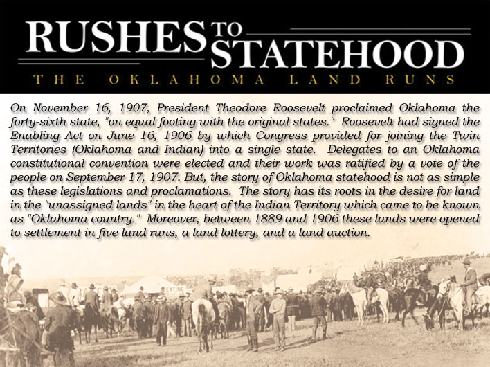
Boomer Movement
In about 1879, Elias C. Boudinot helped to build a strong demand for the opening of these lands. President Rutherford B. Hayes issued a proclamation on April 26, 1879 forbidding trespass into these lands. However, almost immediately, speculators and landless citizens began organizing and agitating for opening the land to settlement. Newspapers referred to these pro-settlement groups as “Boomers.” Boomers were encouraged to plan and participate in excursions or raids into the lands with the objectives of colonization and gaining a legal opinion as to the status of these lands.
In late April 1879 the first organized group of Boomers appeared in Coffeeville, Kansas under the leadership of Colonel C. C. Carpenter. Carpenter assembled a considerable number of families along the southern border of Kansas. They reached the North Canadian River in May 1879 and were duly removed by U.S. troops. Captain David Lewis Payne continued the cause and ignited an Oklahoma boomer movement through his several attempted settlements. The movement gained momentum in 1887 and 1888 when the Santa Fe Railroad constructed a line that ran from Arkansas City, Kansas, directly through the heart of the Oklahoma country to Gainesville, Texas. This increased access and further facilitated the settling of these lands.
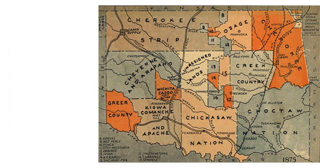
This map shows how the territories that would become the state of Oklahoma looked in 1875, as as represented in The Daily Oklahoman on April 23, 1939.
First Land Run, 1889
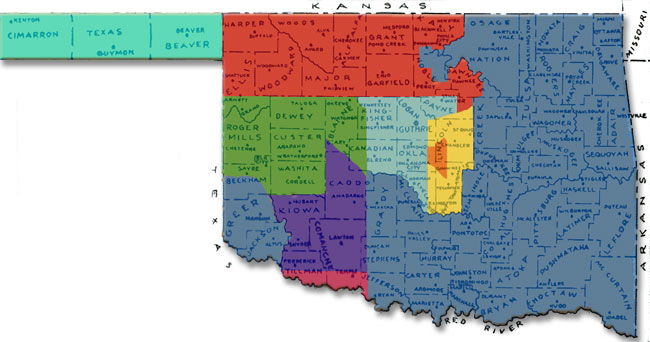
On February 27, 1889 Illinois representative William M. Springer added section 13 to the annual Indian Appropriation bill which authorized the President to open the lands to settlement through issuance of a proclamation. Known as the Springer Amendment, this rider authorized settlement under the provisions of the Homestead Act of 1862 and it denied the original settlers their squatter’s rights. They were to be expelled and the lands were to be settled by a land run. The Act as amended was signed into law by President Grover Cleveland on March 2, 1889. During his third week in office, President Benjamin Harrison issued a proclamation on March 23, 1889 to settle the 1,887,796 acres. In what would be known as the Run of ‘89, eligible persons were authorized to enter at noon on April 22, 1889 for the purpose of occupying a quarter section (160 acres, or ½ mile by ½ mile square). Oklahoma’s first land run opened all or part of the present counties of Canadian, Cleveland, Kingfisher, Logan, Oklahoma, and Payne. Tent cities emerged at the first settlements of Oklahoma City, Kingfisher, El Reno, Norman, Guthrie and Stillwater.
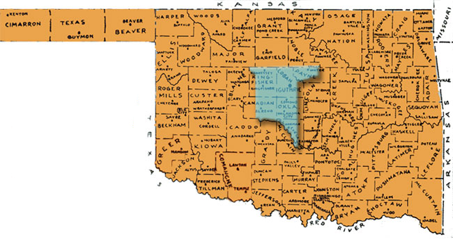
With the exception of Washita and Custer counties this map shows county lines as of 1907, as represented in The Daily Oklahoman on April 23, 1939. Washita and Custer counties have been re-labeled to correct a misprint in the original map.
Second Land Run, 1891
On September 18, 1891, President Benjamin Harrison declared the recently purchased lands (1,120,000 acres) of the Iowa, Sac, Fox, Pottawatomie, and Shawnee tribes to be opened for settlement. Consequently, the second land run began on September 22, 1891 at 12 o’clock noon and the rush to claim one of the 6,097 160-acre homestead was on. Lincoln and Pottawatomie Counties were created. The Oklahoma panhandle, which was then known as “no man’s land,” was opened to settlement by the Oklahoma Organic Act of 1889.
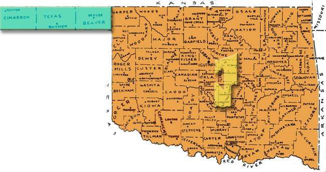
With the exception of Washita and Custer counties this map shows county lines as of 1907, as represented in The Daily Oklahoman on April 23, 1939. Washita and Custer counties have been re-labeled to correct a misprint in the original map.
Third Land Run, 1891
The third land run began at high noon on April 19, 1892 into the lands (4,300,000 acres) of the Cheyenne and Arapaho. Blaine, Dewey, Day, Roger Mills, Custer and Washita Counties date their beginnings from this homestead run of approximately 25,000 citizens.
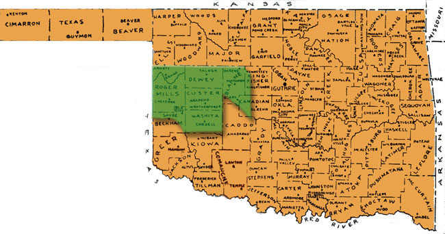
With the exception of Washita and Custer counties this map shows county lines as of 1907, as represented in The Daily Oklahoman on April 23, 1939. Washita and Custer counties have been re-labeled to correct a misprint in the original map.
Fourth Land Run, 1893
At noon on September 16, 1893 the 6,361,000 acres of the Cherokee Outlet was opened to settlement by means of the fourth land run. Congress had purchased the Cherokee land for $8,505,736 or about $1.40 per acre. The Cherokee Outlet was a 60-mile wide strip of land from the 96th meridian west to the 100th meridian. This land is not to be confused with the Cherokee Strip which was a belt of land 2 ½ miles wide that ran along the northern boundary of the Outlet along the 37th parallel. The cities of Enid, Perry, Alva, and Woodward were settled and the counties of Garfield, Grant, Kay, Noble, Pawnee, Woods, and Woodward were established.
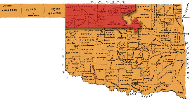
With the exception of Washita and Custer counties this map shows county lines as of 1907, as represented in The Daily Oklahoman on April 23, 1939. Washita and Custer counties have been re-labeled to correct a misprint in the original map.
Fifth Land Run, 1895
On May 3, 1895 the fifth, smallest and final run took place, resulting in the addition of 183,440 acres of Kickapoo lands to Lincoln, Oklahoma and Pottawatomie Counties.
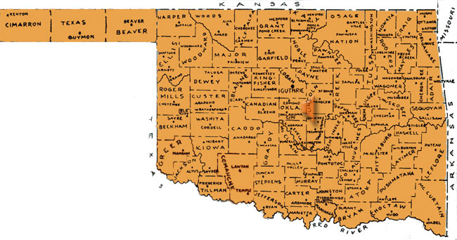
With the exception of Washita and Custer counties this map shows county lines as of 1907, as represented in The Daily Oklahoman on April 23, 1939. Washita and Custer counties have been re-labeled to correct a misprint in the original map.
Land Lottery, 1901
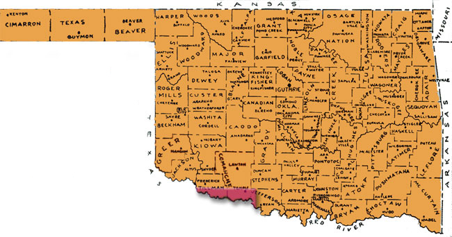
Instead of another land rush, on August 6, 1901 actual settlement of claims to the Wichita-Caddo and Comanche, Kiowa and Apache lands occurred after the drawing of names in a land lottery. With 2,080,000 acres available, nearly 170,000 people registered at El Reno and Fort Sill land offices between July 9 and July 28. The 6,500 names first drawn between July 29 and August 5 were the winners of claims. Kiowa, Caddo, and Comanche Counties were added to Oklahoma Territory.
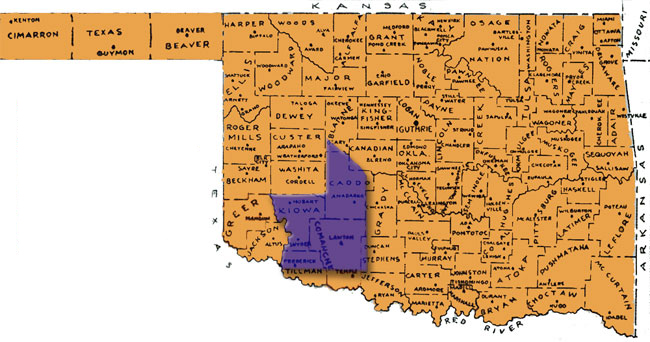
With the exception of Washita and Custer counties this map shows county lines as of 1907, as represented in The Daily Oklahoman on April 23, 1939. Washita and Custer counties have been re-labeled to correct a misprint in the original map.
Land Auction, 1906
Between December 3 and 15, 1906, the United States Land Office accepted sealed bids for quarter sections of land in what was called the ‘Big Pasture’ in Oklahoma Territory. The bids for the half-million acre area bordered on the south by the Red River started on December 17 and continuing until all the quarter sections were sold. Required to live on the land for five years, the bidders could pay in installments during their residency.
With the exception of Washita and Custer counties this map shows county lines as of 1907, as represented in The Daily Oklahoman on April 23, 1939. Washita and Custer counties have been re-labeled to correct a misprint in the original map.
Statehood, 1907
Legislation, proclamations, land rushes, a land lottery, and a land auction, all were factors leading to the settlement and eventual statehood of Oklahoma. At 10:15 on the morning of November 16, 1907, President Roosevelt took a seat at the cabinet table surrounded by a small delegation of government clerks and newspaper men. By 10:16 he signed the statehood proclamation and declared “Oklahoma is now a state.”
With the exception of Washita and Custer counties this map shows county lines as of 1907, as represented in The Daily Oklahoman on April 23, 1939. Washita and Custer counties have been re-labeled to correct a misprint in the original map.